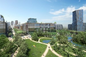
The 7.3-hectare (18 acre) park will connect the long neglected area southeast of downtown to the rest of the city. Designed by renowned design firm Michael Van Valkenburgh Associates, the park will become a vibrant and inviting feature of the new neighbourhood as well as a destination for the entire city.
Stretching from King Street south to the rail corridor in the land west of the Don River and GO/CN railroad lines, Don River Park is the first park in the West Don Lands to begin construction. The park, which is expected to open in late 2011/early 2012, will transform what was an abandoned post-industrial site into a dynamic, year-round, re-naturalized public park, animated by a wide variety of programming and a beautiful multi-functional pavilion.
 Don River Park
"The federal government is proud to be a partner in the revitalization of Toronto's waterfront," said Federal Finance Minister Jim Flaherty. "Our $17.4-million investment will help construct what will be another great new park for residents of Toronto and the people of Canada."
"Today's Don River Park groundbreaking marks the beginning of a new future for the West Don Lands," said Bob Chiarelli, Ontario's Minister of Infrastructure. "The McGuinty government is proud to be a partner in the revitalization of Toronto's waterfront. This park will become an integral part of the community where Ontario families can come to relax, play and enjoy this natural setting."
"Don River Park is yet another of our ambitious undertakings in the ongoing renewal of the Toronto Waterfront," said Mayor David Miller. "This park will not only be a significant greenspace for people to enjoy, it will stand as a testament to all that we have accomplished together and as a future reminder of why waterfront revitalization was so important to this City."
The construction of Don River Park represents the next stage of development in the mostly provincial owned West Don Lands. The 32 hectare (80 acre) West Don Lands is a challenging brownfield site in the flood plain of the Don River and development of the area is contingent on it first being remediated and flood proofed. Construction of the area's flood protection landform, which is designed to protect a 99 hectare (245 acre) area that includes not only the West Don Lands but also Toronto's financial district, is nearing completion. Don River Park is being built on top of the flood protection landform.
"Don River Park is another example of our approach to innovative city building," said Waterfront Toronto Chair Mark Wilson. "By locating and designing the park to take full advantage of the flood protection landform we are leveraging essential public infrastructure to deliver what will be a truly stunning park."
The park was designed to maximize the exceptional topography provided by the flood protection landform. Park features are integrated into the contours and elevation provided by the landform and it capitalizes on the unique landscape to open sightlines to the Toronto skyline, the Don River and Lake Ontario.
The topography organizes the park both physically and programmatically. The river side of the park will be an extensive 3.2 hectare (7.9 acre) urban prairie to address regulations that restrict active recreation and the planting of woody vegetation on the eastern slope of the flood protection landform. The urban prairie will include an upland meadow on the upper parts of the slope, while a lowland wet meadow at the base of the landform will add ecological and experiential diversity. The wet meadow will also be a crucial part of a park-wide ecological stormwater management system. Meandering walking trails, multi-use bike paths, and a boardwalk will also allow visitors to explore the unique urban landscape.
The 3.6 hectare (8.9 acre) western city side of the flood protection landform is defined by a dynamic, unfolding topography that creates varied, flexible spaces for a diverse range of passive and active pursuits. Its features include: a hilltop playground that will offer diverse play experiences for children of all ages; a striking solar powered pavilion that houses the park's washrooms; a youth athletic field that can be used for a variety of organized sports; and a series of open lawns will provide ample space for both informal and organized sports and activities.
Source: http://www.waterfrontoronto.ca/